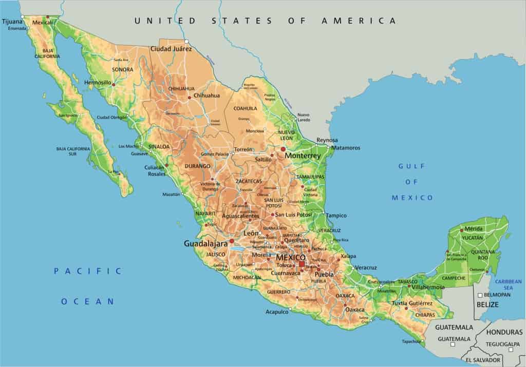
Mexico is located in the Southern portion of North America. Mexico’s northern border is shared with the United States, specifically California, Arizona, New Mexico, and Texas (from west to east). The Pacific Ocean borders Mexico to the west and south, the Gulf of Mexico to the east, and Belize, Guatemala, and the Caribbean Sea to the southeast.
Most of Mexico lies on the North American Plate, but the Baja California Peninsula’s northwestern section rests on the Pacific and Cocos Plates. While some geographers consider the area east of the Isthmus of Tehuantepec (including the Yucatán Peninsula) part of North America, this classification is not universally accepted.
Mexico is the 13th largest country in the world with an area of 761,610 sq mi (1,972,550 km2) including approximately 6,000 square kilometers of islands in the Pacific Ocean, Gulf of Mexico, Caribbean Sea, and Gulf of California. Mexico has a substantial number of islands, with estimates reaching nearly 4,000! This includes a wide range of sizes, from small islets to larger, inhabited islands. These islands are located along the Baja California Peninsula, both in the Pacific Ocean and the Gulf of California (Or Sea of Cortez) and, around the Yucatan Peninsula and in the Gulf of Mexico.

Mexico’s Geographic Regions
While researching I found various ways to divide Mexico into geographical regions. I decided to go with a division of 10 regions:
1. Baja California Peninsula. (Peninsula de Baja California)
2. The Mexican Plateau. (Antiplano Mexicano)
3. Eastern Sierra Madre. (Sierra Madre Oriental)
4. Western Sierra Madre. (Sierra Madre Occidental)
5. Southern Sierra Madre (Sierra Madre del Sur)
6. The Mexican Trans-Volcanic Belt. (Cordillera Neo-Volcánica.)
7. The Pacific Plain. (Llanura del Pacífico)
8. The Atlantic-Gulf Coastal Plain. (Llanura del Atlántico-Golfo)
9. The Southern (Chiapas) Highlands. (Tierras Altas del Sur (Chiapas)
10. The Yucatán Peninsula. (Peninsula de Yucatán)
Here is a geographical map showing the characteristics of its land.
Now let’s have a close look at each area:
1. Baja California
Baja California, a long and narrow peninsula in northwestern Mexico, separates the Pacific Ocean from the Gulf of California. Its terrain is rugged, featuring the Sierra de Baja California mountain range, which includes the Sierra de Juárez and Sierra de San Pedro Mártir, culminating in Picacho del Diablo, the peninsula’s highest peak. It comprises two Mexican States: Baja California and Baja California Sur.

This photo of Baja California features San Felipe, a town in the north facing the Pacific Ocean.


Here you can also see the beautiful rock formation of El Arco de Cabo San Lucas:

Enjoy this video that will make you feel that you are there… or perhaps want to go there!
2. The Mexican Plateau (Antiplano Mexicano)
The Central Mexican Plateau, also called the Antiplano Mexicano is a vast arid to semiarid plateau located across much of northern and central Mexico. The Mexican Plateau is mostly covered by deserts and xeric shrublands, with pine-oak forests covering the surrounding mountain ranges and forming sky islands on some of the interior ranges.
Sky islands are isolated mountains surrounded by radically different lowland environments. The term originally referred to those found on the Mexican Plateau and has extended to similarly isolated high-elevation forests.

Though considered by geographers as one Plateau or Mesa, the Central Mexican Plateau is bisected by a low east-west mountain range in Zacatecas, creating the Northern Plateau (Mesa del Norte) and the Central Plateau (Mesa Central).
MESA DEL NORTE
The Mesa del Norte, the northern portion of the Mexican Plateau, averages 1,100 metres (3,600 ft) in elevation above mean sea level and extends south from the Rio Grande (Río Bravo del Norte) through the states of Chihuahua, Coahuila, Durango, Zacatecas and San Luis Potosí.It presents a fascinating array of formations and landforms, largely shaped by its arid to semiarid climate. Here’s a breakdown of some key features:
Arid Landscapes:
The region is characterized by extensive arid and semiarid landscapes, with the Chihuahuan Desert occupying a significant portion. This results in sparse vegetation and distinct desert ecosystems.
Intermontane Basins and Bolsónes:
The Mesa del Norte features relatively flat intermontane basins and “bolsones.” Bolsónes are internal drainage basins, meaning water collects within them and doesn’t flow to the sea. The Bolsón de Mapimí is a prominent example. These depressions contribute to the unique hydrology of the region.

This area has the Mapimí Biosphere Reserve, a UNESCO Biosphere Reserve located in the state of Durango in northern Mexico. It is one of three biosphere reserves representing the Chihuahuan Desert. In this reserve there are 403 plant species. Noteworthy are the 39 cactus species (9 of which are endemic) and 200 species of birds, 5 species of amphibians, 36 species of reptiles and 28 species of mammals.
These is the Nopal Cacti or Nopales, a fleshy, arboreal cactus plants which grow between one and five metres high.


The flat green pads of the cactus are the nopales. In the upper part of the stalks, you will find red, purple and yellow flowers along with the prickly pear which are a delicious fruit with crunchy seeds.
Nopales are the most common variety of consumed cactus. It has a wide range of culinary applications. It may be prepared through grilling, roasting, or stewing, serving as a complement to various dishes. Moreover, it is a common ingredient in Mexican salads. Nopal flour, derived from cactus, is also utilized in the production of high-fiber baked goods, such as biscuits. And of course it is eaten in quesadillas!
This is the process in photos of making a salad with nopales from a website called Directo al Paladar.


and here are some quesadillas con nopales:

Geez this is making me way too hungry , ket’s move on to another variety of cactus:
This is: Mammillaria magnimamma Haw, commonly known as Mexican Pincushion:


MESA CENTRAL (Mexican Plateau)
The Mesa Central It extends across the states of Aguascalientes, Jalisco, Zacatecas, Guanajuato, Querétaro, and Michoacán. Compared to the Mesa del Norte (Northern Plateau), the Mesa Central generally has a higher elevation, which contributes to a more temperate climate. This region contains numerous fertile valleys and plains, often formed by ancient lakebeds. This makes it a prime area for agriculture. Both of these characterisitics (better climate and prime areas for agriculture) have contributed to a greater concentration of human settlement and here is where you find the most populated cities of Mexico.
Another incredible place located in the Mesa Central I want to highlight is a cave, called ‘Sótano de las Golondrinas’ (The Cave of the Swallows).
This cave is located in Aquismón, San Luis Potosí, Mexico. It is a open-air pit cave features an elliptical entrance, measuring approximately 161 by 203 feet, on a slope. The cave’s interior expands to approximately 994 by 443 feet, with a floor that plunges roughly 1,093 to 1,214 feet, making it the world’s largest known cave shaft. Imagine that you could fit the entire Chrysler building (from NYC) inside!


To see people jumping into it…
3. La Sierra Madre Oriental
The Sierra Madre Oriental, a mountain range in northeastern Mexico, forms part of the American Cordillera. This extensive cordillera is a near-continuous chain of mountain ranges that constitutes the western backbone of North, Central, and South America, as well as Antarctica.
From its origin at the Rio Grande, along the Coahuila-Texas border, the Sierra Madre Oriental runs 1,000 kilometers (620 mi) south. It passes through Nuevo León, southwest Tamaulipas, San Luis Potosí, Querétaro, and Hidalgo, ultimately connecting with the Eje Volcánico Transversal in northern Puebla.


Cr. Wikimedia Commons, William L. Farr

In the northern part of Sierra Madre Oriental in Nuevo León, “Cumbres de Monterrey” National Park offers a diverse landscape. Designated a national park in 1939, it encompasses 952 square miles (2,465 square km) of mountainous terrain. The park’s main features are the peaks of the Sierra Madre Oriental, many rising above 7,000 feet (2,100 metres) and adorned with pine and oak forests on their lower slopes. Visitors can also explore the Huasteca Canyon ecological park near Monterrey and marvel at the 82-foot (25-metre) Cola de Caballo waterfalls, situated southwest of Santiago.


Also in this area at the Huasteca Potosina are incredible waterfalls. The following photos shows the Tamul Waterfall.


For more incredible photos and information check out Jess Wandering’s Blog HERE.
In this video you can see this one and many other waterfalls in thte area:
Established to safeguard the region’s distinctive ecology, “La Reserva de la Biosfera Sierra Gorda”: this” is a protected area in the southern Sierra Madre Oriental encompassing 193 named mountains, including its highest peak, La Pingüica, and most prominent, Cerro La Joya.

This nature reserve alone boasts more than 5000 species of animals and plants. These include include mule deer, coyotes, mountain lions, jaguarundis, jaguars, white-nosed coati, and black bears. There are also dozens of species of birds, including maroon-fronted parrots, golden eagles, peregrine falcons, colima warblers, and wild turkeys.

A Jaguarundi. Cr. ©Joaquin S. Muller. CC BY-NC-SA 4.0


This cactus plant is a tree-like growing with multiple candelabra-shaped branches, up to 5–7 m (16–23 ft), with a central trunk followed by many upturned branches. It grows in the Sierra Madre and the Mexican states of Colima, Edomex, Guanajuato, Jalisco, Michoacán, Nayarit, Querétaro and Zacatecas, growing in deciduous forests and dry shrublands at altitudes of 0 to 1800 meters. It gives a fruit called the Pitaya fruit once a year starting the month of April. A full adult plant (about 15 years old) can produce a Pitaya a day. The season is about two months so one plant can produce about 60 pitayas per season.
This is what the fruits look like once they are peeled:

…and cut. Yes! They are very sweet!

This video shows why this fruit is very expensive:
The forests of the Sierra Madre Oriental also play a substantial role as part of the migration route of the monarch butterfly.
The forests of the Sierra Madre Oriental also play a substantial role as part of the migration route of the monarch butterfly. There are two major monarch migrations, one on the eastern side and one on the western side. The eastern migration is the longest covering 3,000 miles beginning from their breeding grounds in Canada and the North East of the United States.
The monarch butterfly migration occurs in a seasonal cycle, involving both southward and northward movements. The fall migration (southward) starts in August and continues through October. Eastern monarchs spend their winter in the mountainous forests in central Mexico, most at the Chincua Monarch Butterfly Biosphere Reserve in the states of Michoacán and México. This reserve hosts aproximately 60 million butterflies that overwinter in oyamel fir forests at high elevations within this reserve.


4. The Sierra Madre Occidental
Stretching 1,250 km (780 mi) southeast from just below the Arizona-Sonora border, the Sierra Madre Occidental parallels Mexico’s Pacific coastline. The range passes through eastern Sonora, western Chihuahua, Sinaloa, Durango, Zacatecas, Nayarit, Jalisco, Aguascalientes, and Guanajuato, where it connects with the Sierra Madre del Sur and the Transverse Volcanic Axis. In the north, it lies 300 km (190 mi) from the Gulf of California, but approaches within 50 km (30 mi) of the Pacific Ocean in the south.

Mexico’s Sierra Madre Occidental remains a significantly remote area. Travel through the range is particularly challenging due to the scarcity of paved roads, despite the presence of numerous small communities, notably in Copper Canyon (Barrancas del Cobre).
Barrancas del Cobre / Copper Canyon
Copper Canyon, a 25,000 sq mi (65,000 sq Km) region in southwestern Chihuahua, northwestern Mexico, is a system of canyons carved by six rivers. These rivers, draining the western Sierra Tarahumara (part of the Sierra Madre Occidental), converge into the Rio Fuerte, which empties into the Gulf of California. The canyons’ copper/green walls give the region its name. Some of the individual canyons within its system are considerably deeper than portions of the Grand Canyon!


Climate and ecology in the Sierra Madre Occidental are highly dependent on location along the mountain range. Seasonal temperature and moisture variations are significant, due to the region’s proximity to both the Atlantic and Pacific Oceans.
The Sierra Madre Occidental pine-oak forests ecoregion, covering roughly 222,700 square kilometers (86,000 sq mi) of western Mexico, encompasses a significant portion of the Sierra Madre Occidental mountain range.
Copper Canyon traditional inhabitants are the Tarahumara or Rarámuri. With no official census, the population of the Rarámuri people probably ranges between 35,000 and 70,000. Many Rarámuri reside in the cooler, mountainous regions during the hot summer months and migrate deeper into the canyons in the cooler winter months, where the climate is more temperate. Their survival strategies have been to occupy areas that are too remote for city people, way off-the-beaten-path to remain isolated and independent so as to avoid losing their culture.
They are known for being great long distance runners. In fact their name Rarámuri means “The Running Feet” in their native language.


Among them there is a woman that became famous as she won first place in an Ultra marathon in Puebla, and later on placed Third in an international one in Spain. Her name is Maria Lorena Ramirez.

Drug violence and cultivation, prevalent in the Sierra Madre’s fertile drug-growing region, have severely impacted the Rarámuri. Illegal logging, often linked to drug cartels laundering money, further disrupts the region. Cartels force Rarámuri farmers to cultivate drugs and exploit their long-distance running abilities for trafficking into the United States.
5. La Sierra Madre del Sur
The Sierra Madre del Sur stretches approximately 620 mi (1,000 km) from Michoacán through Guerrero to eastern Oaxaca. As a component of the Sierra Madre Mountain System, the Sierra Madre del Sur joins the Sierra Madre Occidental, Sierra Madre Oriental, and the Sierra Madre Chiapas.

The higher elevations of the Sierra Madre del Sur harbor subtropical coniferous forests, characterized by a diverse mix of oak and pine species. Within this ecoregion, oak forests are particularly prevalent between 1,900 and 2,500 meters (6,200-8,200 feet) in elevation, dominated by species such as Quercus magnoliifolia (encino amarillo) and Pinus montezumae (Montezuma pine). These forests play a crucial role in maintaining local water cycles and soil stability.

Above 2,300 meters (7,500 feet), substantial cloud forests emerge, distinguished by persistent condensation and moisture-laden air. These unique ecosystems support a distinct assemblage of species, including Abies guatemalensis (Guatemalan fir), Abies religiosa (sacred fir), Pinus ayacahuite (Mexican white pine), and Cupressus lusitanica (Mexican white cedar). Cloud forests are vital for capturing atmospheric moisture, which contributes significantly to regional water resources.

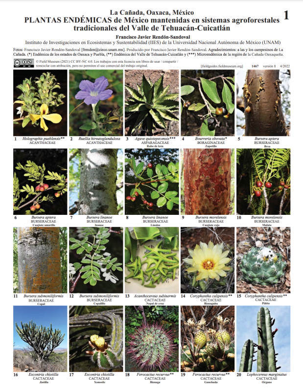
The Sierra Madre del Sur’s biodiversity is exceptionally rich, with nearly 600 plant species recorded. Notably, 7 plant genera and 161 species are endemic to Mexico, highlighting the region’s unique flora. A remarkable concentration of endemism is found in Cañón del Zopilote, a small canyon on the range’s periphery, where 16 plant species are exclusively found.
I was able to find this Field Guide of Endemic plants from the region of Oaxaca:
The region also supports a diverse fauna, including over 150 butterfly species, approximately three dozen reptile species, and more than 50 mammal species. Furthermore, the Sierra Madre del Sur is recognized as one of the world’s most biodiverse regions for birdlife. For example, Guerrero holds the world’s fourth-highest bird richness, with 160 species in the ecoregion, 28 of which are endemic. Notable endemics include the short-crested coquette, white-tailed hummingbird, Oaxaca hummingbird, and white-throated jay. This rich biodiversity is a result of the region’s varied topography, diverse microclimates, and complex geological history.

Parque Nacional Grutas de Cacahuamilpa
Home to one of the world’s most impressive cave systems, Parque Nacional Grutas de Cacahuamilpa attracts many visitors. This park, nestled in the northern Sierra Madre del Sur, allows exploration of its subterranean wonders, with tours along two rivers and through numerous chambers.
The cave system, renowned for its massive chambers adorned with spectacular stalactites and stalagmites, showcases the dramatic effects of water erosion on limestone over millennia. These formations, ranging from delicate, straw-like structures to colossal, column-like features, create a surreal and captivating landscape. The two subterranean rivers, Rio Chontalcoatlán and Rio San Jerónimo, have carved out these vast passages, adding to the cave’s dynamic and awe-inspiring environment.


I hope you enjoyed this first part of the stunning geography of Mexico. Part II coming soon!
