In my last post I covered five of the ten geographical regions of Mexico: Baja California Peninsula, The Mexican Plateau, The Sierra Madre Oriental, the The Sierra Madre Occidental & the Sierra Madre del Sur. In this post, I will cover the rest: The Mexican Trans-Volcanic Belt, The Pacific Plain, The Southern (Chiapas) Highlands, The Atlantic-Gulf Coastal Plain & The Yucatán Peninsula. I will also cover some islands of Mexico.
The Cordillera Neo-Volcánica (The Trans Mexican-Volcanic Belt)
Known locally as the Sierra Nevada, the Trans Mexican-Volcanic Belt stretches east from Colima and Jalisco, through central Mexico to Veracruz. North of it lies the Mexican Plateau, bordered by the Sierra Madre Occidental and Oriental. The Cofré de Perote and Pico de Orizaba volcanoes mark the belt’s eastern convergence with the Sierra Madre Oriental. South of the belt, the Balsas River basin separates it from the Sierra Madre del Sur.
It traverses multiple Mexican states from west to east, including Colima, Jalisco, northern Michoacán, Guanajuato, southern Querétaro, México, southern Hidalgo, Distrito Federal, northern Morelos, Puebla, Tlaxcala, and central Veracruz.


The Trans-Mexican Volcanic Belt was formed by the subduction of the Cocos and North American tectonic plates. As the Cocos plate slides beneath the North American plate, it melts, and the resulting magma rises to the surface, creating a chain of volcanoes.
The highest point of the Mexican Trans-Volcanic Belt, also the highest point in Mexico, is Pico de Orizaba (5,636 metres (18,491 ft)) also known as Citlaltépetl.

Let’s go there… ready?
(Remember to click to another dot to move around… incredible huh?
A few facts about Citlaltépetl:
Its Nahuatl name, Citlaltépetl, means “Star Mountain.”
It’s the highest mountain in Mexico and the third highest peak in North America. It rises to an elevation of 18,491 feet (5,636 meters).
It’s considered a dormant volcano, with its last confirmed eruption occurring in 1846.
Pico de Orizaba is one of the few volcanoes in Mexico that supports glaciers, and it is home to the largest glacier in Mexico, the Gran Glaciar Norte.
Ready to descend the Gran Glaciar Norte?
I wonder what having humans walking over glaciers does to them… it can’t be good if too many people go climbing them… and they are one of our sources of fresh water…


Volcán de la Colima. Eruption.
One important thing to note is that the lower part of the Mexican plateau crosses into the Trans-Volcanic belt geographical area. This area with better climate and prime areas rich in minerals for agriculture have contributed to a greater concentration of human settlement. Here is where you find some the most populated cities of Mexico.
Some of these cities are Mexico City, Guadalajara, and Puebla. Due to the amount of information we have yet to cover I will only highlight a bit of Mexico City.
Mexico City is around the Sixth most populated city (with metro area) in the world with about 22,752,400 million people as of 2025. (1)
It was originally founded by the Aztecs in 1325 as Tenochtitlan, built on islands in Lake Texcoco. This indigenous heritage is still visible in archaeological sites like the Templo Mayor.

The Templo Mayor stood as the heart of Tenochtitlan, the bustling Aztec (Mexica) capital that once housed over 200,000 people. Some even considered it the universe’s center. Following Hernán Cortés’s 1521 conquest, the city, including the Templo Mayor, was largely destroyed. As a symbol of Spanish dominance, the 17th-century Mexico City Cathedral was erected on the ruins.

When doing some repairs to the cathedral, a huge stone depicting the Aztec Calendar was found in 1790. It was buried by the Spaniards shortly after their conquest. Weighing almost 55 lb and mesuring around 12 ft is considered one of the surviving masterpieces carved by the Mexica (Aztecs). It is housed in the National Anthropology Museum in Mexico City.

The Aztec calendar system combined two cycles: a 365-day solar calendar, the xiuhpōhualli (year count), used for agriculture, and a 260-day ritual calendar, the tōnalpōhualli (day count), considered sacred. These cycles meshed to form a 52-year period known as the “calendar round.”
If you are interesting in trying to understand how the Mexica’s calendar’s worked check out this video. Absolutely fascinating!
There are many other historic places in Mexico City like it’s main Zócalo (square), the main Cathedral (Catedral Metropolitana), El Palacio Nacional that houses the impressive murals by Diego Rivera, the area of Coyoacán where you can visit Frida Kahlo’s Casa Azul and the Chapultepec Castle (a castle that served as a residence for emperors, presidents, and now houses the National Museum of History.) I will cover more of the history of this incredible city in another post.
The way the Aztecs planted in “Chinampas” has been miraculously saved in the area of Xochimilco:
let me guess what you want to learn about next…

Axolotls!
The axolotl, a critically endangered salamander native to the shrinking lake system of Xochimilco, Mexico, is a creature of remarkable biological quirks. Perhaps its most striking trait is neoteny, the retention of larval characteristics into adulthood, resulting in its feathery external gills and a perpetually “young” appearance. Unlike most salamanders, axolotls remain fully aquatic throughout their lives.
Adding to their mystique is their extraordinary regenerative ability, allowing them to regrow limbs, organs, and even parts of their brain and heart without scarring—a feature that has made them invaluable subjects in scientific research. These carnivores, feeding on small aquatic life, display a range of color variations in captivity, from the wild’s dark hues to vibrant pinks and golds.
Despite their “walking fish” nickname, they are amphibians, a testament to their ancient lineage. Sadly, their natural habitat faces severe threats from pollution and urbanization, placing these fascinating creatures on the brink of extinction.
Here is a guide made by Ellie’s Axolotls:
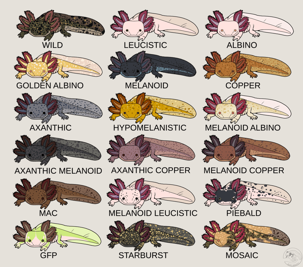
Did you wonder the GFP Axolotl? Me too!
A “GFP axolotl” refers to axolotls with the “GFP” gene, which stands for Green Fluorescent Protein. It’s not a separate breed or species, but rather a genetic modification that makes them glow under ultraviolet (UV). It was introduced by scientists so they could study the axolotls, especially their regenerative capacity.
Before moving to the next geographical zone, I wanted to share that Mexico is a country with a long history of significant seismic activity due to its complex geological setting. It lies at the intersection of several major tectonic plates, including the North American Plate, the Cocos Plate, the Pacific Plate, and the Caribbean Plate. The subduction of the Cocos Plate beneath the North American Plate along the Pacific coast is the primary source of many of Mexico’s powerful earthquakes. And many of these earthquakes have affected Mexico City and its surrounding areas causing the loss of countless lives.
Some of the most devastating earthquakes recently are: Some of the most significant include:
1985 Mexico City Earthquake: This magnitude 8.0 earthquake on September 19th caused widespread destruction in Mexico City, resulting in thousands of deaths and the collapse of numerous buildings. The city’s location on the soft soil of an ancient lakebed amplified the seismic waves, exacerbating the damage.
2017 Chiapas Earthquake: A powerful magnitude 8.2 earthquake struck off the coast of Chiapas on September 7th. While the damage was significant in the southern states, Mexico City, located further away, experienced strong shaking but less widespread damage compared to 1985. This earthquake also generated a small tsunami.

The Pacific Belt (Llanura del Pacífico)
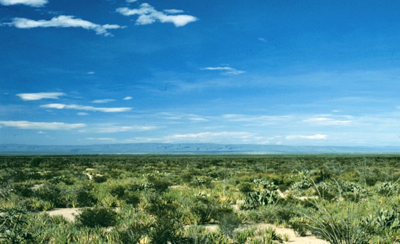
The Pacific Coastal Plains of Mexico extend along the western coastline from the Colorado River Delta to near Tepic, covering areas in Sonora, Sinaloa, Nayarit, and Jalisco. The region is characterized by a coastline that faces the Gulf of California for much of its length and then opens to the Pacific Ocean. It covers a distance of about 900 miles (1,450 km).
The Pacific coast features rolling hills, cliffs, and beaches with white to ochre sands. The vegetation varies from arid desert to Mediterranean-style scrub and luxuriant forest, depending on the specific location.
Part of this coast is referred as the ‘Mexican Riviera,’ a heavily developed stretch from Puerto Vallarta to Acapulco, boasting Mexico’s highest concentration of beach resorts and attracting millions of visitors annually. However, the Yucatán Peninsula now draws a significant portion of this beach tourism as well.

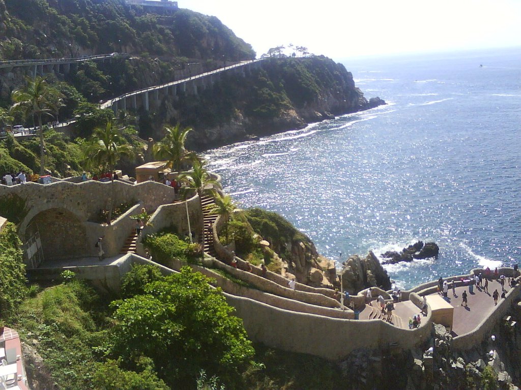
Acapulco
Acapulco, Mexico, is a renowned coastal city famed for its stunning beaches, vibrant nightlife, and dramatic cliff divers. Once a glamorous hotspot for Hollywood stars in its 1950s-60s golden age, gave way to decline from the 1980s onward. Competition from newer resorts and rising security concerns significantly impacted its tourism.


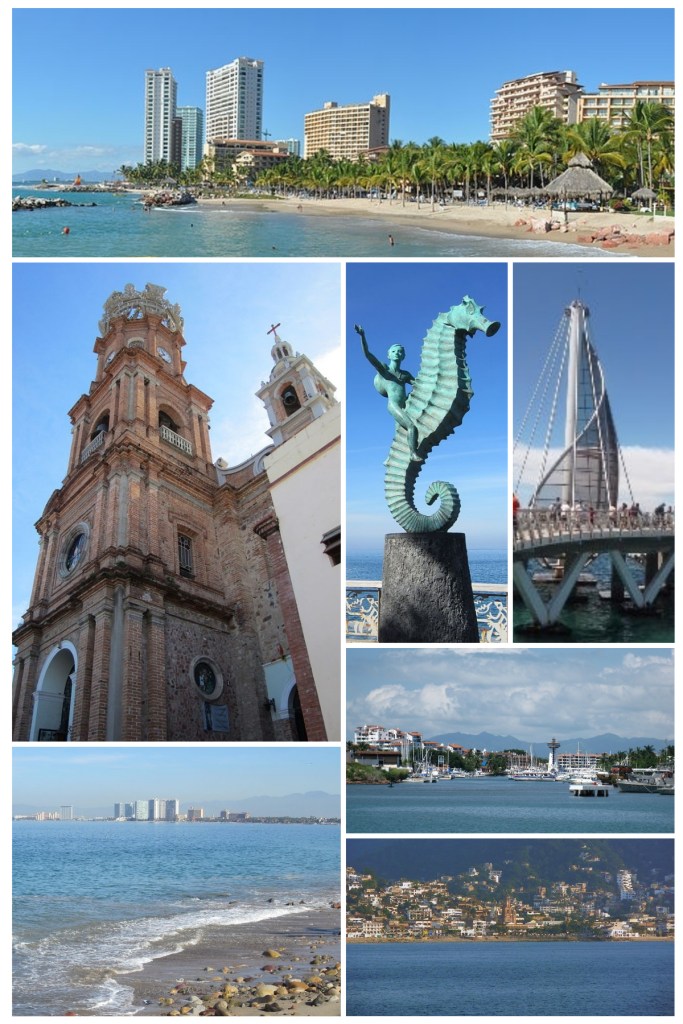
Puerto Vallarta
Puerto Vallarta, a coastal city in Jalisco, Mexico, began its transformation into a tourist destination in the 1960s. Its rise was significantly boosted by Hollywood attention, particularly after the filming of “The Night of the Iguana” (1964) starring Elizabeth Taylor and Richard Burton at Mismaloya Beach. This drew international attention to its scenic beauty and charm. This exposure, combined with its natural attractions, spurred its rapid development.


Marietas Islands (Islas Marietas, Nayarit)
These islands are a protected national park, famous for their hidden beach, “Playa Escondida” or “Hidden Beach,” which is accessible through a water tunnel. They are also a sanctuary for diverse marine life, including coral reefs, dolphins, and humpback whales (in season). The unique geological formation of the hidden beach is stunning!

The Southern (Chiapas) Highlands. (The Sierra Madre de Chiapas)
One could say that the Sierra Madre de Chiapas is the continuation of the Sierra Mare del sur, and then this range of mountains continues on to western Guatemala, into El Salvador and Honduras.
The Chiapas Range, primarily in Mexico’s Chiapas state, extends from Oaxaca, Veracruz, and Tabasco into Guatemala, where it’s also known as Sierra de las Nubes. It’s part of the Western American cordillera, bordered by the Sierra Madre del Sur and Cordillera Neovolcánica to the west, and the Yucatan peaks to the east, transitioning into the Guatemala and Central American ranges to the south.
Within it there is a nature reserve called “Reserva de la Biosfera del Triunfo,” home to about 1/4 of the animal species of México.
El Triunfo contains a variety of plant communities (tropical dry, evergreen moist, pine-oak), with 977 recorded plant species. Its significance lies in its extensive, biodiverse cloud forests, among Mexico’s largest, thriving in high-rainfall mountain areas.
The reserve is home to 548 terrestrial vertebrate species. This represents approximately 45% of the terrestrial vertebrate species recorded for the state of Chiapas. It also accounts for about 22% of those recorded for all of Mexico.
The reserve hosts a very high number of bird species. Reports indicate that the reserve holds around 381 bird species. This makes it a very important location for bird conservation in Mexico. Among these birds is the Resplendent Quetzal (Pharomachrus mocinno), a bird of immense cultural and ecological importance.

There is also a very curious looking bird called Horned Guan (Oreophasis derbianus).


Parque Nacional Cañón del Sumidero
This park, located in Chiapa de Corzo, within the Chiapas Range, Cañón del Sumidero National Park was created in 1980 to safeguard the Sumidero Canyon, a 13km gorge with 1,000-meter-high walls, formed by the Grijalva River.

Palenque
Another treasure of Chiapas is Palenque. Palenque is an ancient Maya city located in the modern-day Mexican state of Chiapas. It’s renowned for its stunning archaeological ruins, which offer a glimpse into the sophisticated civilization that once thrived there.
Palenque was a major Maya city-state that flourished during the Classic period (c. 600-900 AD). It was a significant political and ceremonial center. One of Palenque’s most famous rulers was K’inich Janaab’ Pakal, or Pakal the Great. His tomb, discovered within the Temple of the Inscriptions, is a remarkable archaeological find.
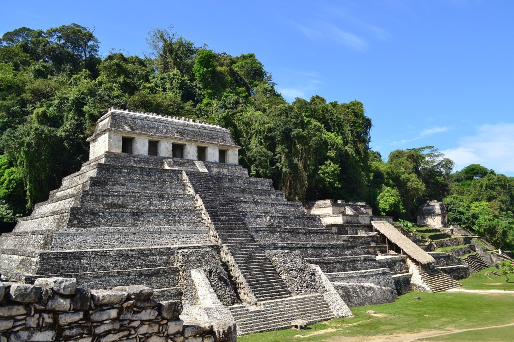


Palenque is known for its extensive and well-preserved hieroglyphic inscriptions, which have provided valuable insights into Maya history, mythology, and royal lineages.
The site features impressive Maya architecture, including temples, palaces, and intricate carvings.
The Temple of the Inscriptions, the Palace, and the Temples of the Cross Group are among the most notable structures. Palenque is nestled in the lush jungles of Chiapas, creating a dramatic and evocative setting.
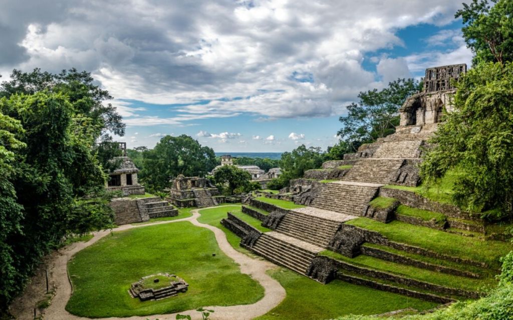
The archaeological site and the surrounding Palenque National Park are designated as a UNESCO World Heritage Site.
The Atlantic-Gulf Coastal Plain (Llanura Costera del Golfo)
The Gulf Coastal Plain of Mexico, a broad expanse of low-lying terrain, presents a stark contrast to the narrower Pacific Coastal Plains. This region extends along the Gulf of Mexico coastline, beginning at the northernmost point in the state of Tamaulipas, where it shares a border with the U.S. state of Texas. From this northern boundary, it sweeps southeastward, encompassing the states of Veracruz and Tabasco, and ultimately reaching the Yucatán Peninsula. A notable feature within this vast plain is the Tabasco Plain, situated in the southeastern portion, characterized by its flat topography and extensive wetlands.
The Gulf Coastal Plain is distinguished by its warm, humid climate, which fosters a dense and varied vegetation cover. This climate, coupled with fertile soils, has made the region a crucial agricultural zone, supporting the cultivation of crops such as sugarcane, citrus fruits, and tropical produce. Furthermore, the area is rich in natural resources, particularly petroleum, contributing significantly to Mexico’s energy sector.
Beyond its economic importance, the Gulf Coastal Plain is a region of substantial ecological significance. Its diverse ecosystems, including coastal lagoons, mangrove forests, and tropical rainforests, provide habitats for a wide array of plant and animal species. The region’s biodiversity is further enhanced by the presence of numerous rivers and wetlands, which contribute to its ecological richness. However, this ecological wealth faces challenges from human activities, including agricultural expansion, industrial development, and urbanization.
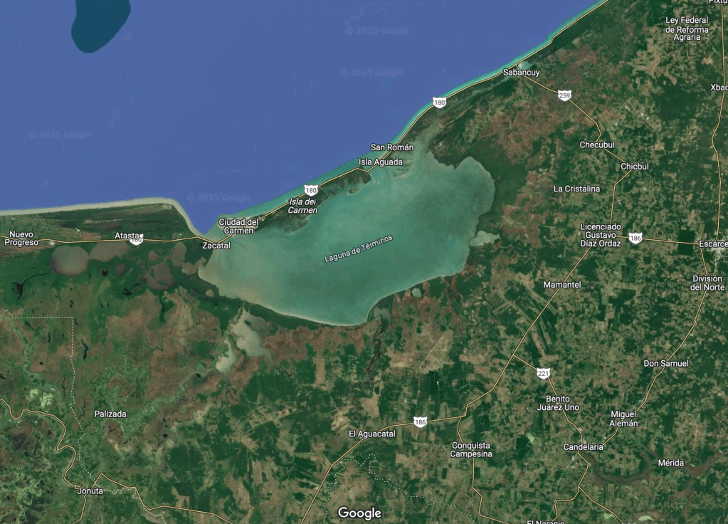
Laguna de Terminos
In the state of Campeche, along the southeastern coast of Mexico, lies Laguna de Términos. This shallow, swirling body of water, where wetlands and rivers converge, is Mexico’s largest coastal lagoon, covering 2500 square kilometers.
A defining characteristic of coastal lagoons is their restricted connection to the ocean. In Laguna de Términos, Isla del Carmen, a 2.5-kilometer-wide barrier island, significantly restricts the water flow between the lagoon and the Campeche Sound. This creates a system with two primary inlets (or outlets), where seawater generally flows into the lagoon on the eastern side of the island and out on the western side.

The Yucatán Peninsula
The Yucatán Peninsula is a large landmass in southeastern Mexico that extends into parts of Belize and Guatemala. It separates the Gulf of Mexico from the Caribbean Sea and is known for its rich Mayan history, diverse ecosystems, and popular tourist destinations.
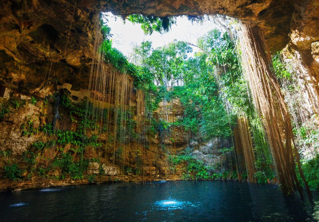
The peninsula is a low-lying limestone platform with a tropical climate, ranging from semi-arid in the northwest to humid in the south. A unique feature is the lack of surface rivers in the northern part due to the porous limestone, which has led to the formation of numerous cenotes (natural sinkholes connected to underground water systems). The eastern coast along the Caribbean Sea is known for its beautiful beaches and coral reefs.
The Yucatán Peninsula has an estimated 10,000 cenotes! Sadly, many are now facing potential risks from the construction of the new tourist Maya Train.
THis beauty is the “Ik Kil” Cenote, meaning “The Sacred Blue Cenote.”

This is Cenote Zapote and Hells Bells in Cancún, México:
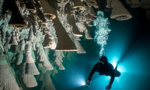
Ready to dive? Let’s do this! ^ ^
The Yucatán Peninsula was the heartland of the Mayan civilization, which flourished for centuries and left behind impressive archaeological sites. Today, a significant portion of the population is of Mayan descent, and Mayan languages are still spoken. The region also has a strong Spanish colonial influence, evident in the architecture and traditions of its cities.
Chichén Itzá
Chichén Itzá is the most famous Mayan site, a UNESCO World Heritage Site and one of the New Seven Wonders of the World. Highlights include the iconic Kukulkan Pyramid (El Castillo), the Great Ball Court, and the Sacred Blue Cenote (previously featured in the text).
The presence of two large cenotes on the site made it an ideal location for the city, which derived its name from the Maya words chi (“mouths”), chen (“wells”), and Itzá, the name of the Maya tribe that settled there.
Located in south-central Yucatán state, Mexico, the extensive ancient Maya ruins of Chichén Itzá, covering 4 square miles (10 square km), are thought to represent a major religious, military, political, and commercial center that may have reached a population of 35,000.
The following is perhaps its most famous structure. The Temple of Kukulcan.Known in Spanish as “El Castillo.” It was built by the pre-Columbian Maya civilization sometime between the 8th and 12th centuries CE, the building served as a temple to the deity Kukulcán, the Yucatec Maya Feathered Serpent deity closely related to Quetzalcoatl, a deity known to the Aztecs.

All four sides of the temple have approximately 91 steps which, when added together and including the temple platform on top as the final “step”, may produce a total of 365 steps (the steps on the south side of the temple are eroded).
Sculptures of plumed serpents run down the sides of the northern balustrade. Around the spring and autumn equinoxes, the late afternoon sun strikes off the northwest corner of the temple and casts a series of triangular shadows against the northwest balustrade, creating the illusion of the feathered serpent “crawling” down the temple.
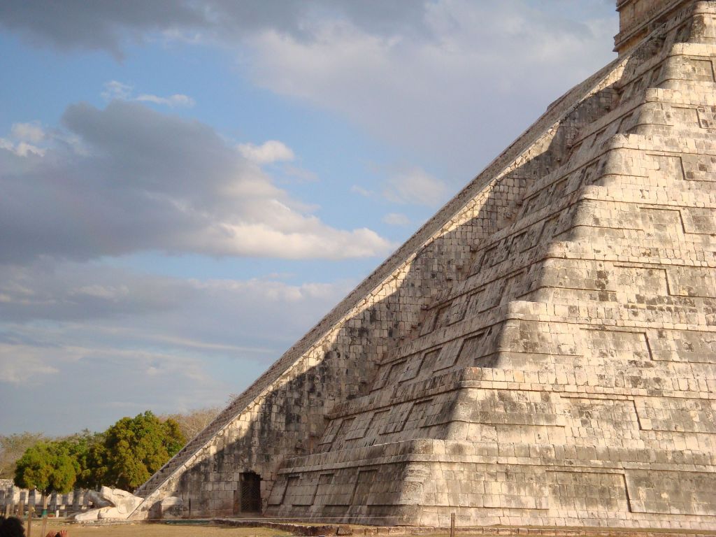

A unique acoustic property of the temple, discovered through scientific research since 1998, is its ability to echo the chirping sound of the quetzal bird when hands are clapped around it. Researchers believe this was an intentional design element, with the builders possibly interpreting the echo as a divine affirmation of their efforts. My jaw just dropped to the floor… This is incredible!
Well we have come to the end of this geographical trip around Mexico… thank you for coming along!
